Lost Cause: NY and Confederate History

The fact that New York State has no official celebration of the Civil War Sesquicentennial or the War of 1812 Bicentennial is no secret. The question that isn’t being asked is: Why not?

To say that New York doesn’t have the money misses the point. Every state has financial problems but somehow other states are able to do something officially on the state level on behalf of these historic anniversaries. Why not New York? Hasn’t New York always generously supported historical anniversaries in the past? :) Read more

War of 1812: Carrying the Great Rope

During the War of 1812, control of Lake Ontario was one of many issues considered critical by both sides. A key position for the British was Kingston, Ontario, about thirty miles north of the vital American base at Sackets Harbor. In an effort to establish domination of the lake, the two sites engaged in a shipbuilding race.

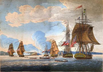
The British finished first and gained control, but American builders quickly completed three new ships (two brigs and the huge frigate Superior, larger than its British counterpart). Their launch required only weapons and rigging, which were en route from Brooklyn via Albany. In 1814, hoping to keep those vessels in port, the British sought to disrupt American supply routes. A prime target was Fort Ontario, located at Oswego on the mouth of the Oswego River.


On May 5, the British fleet launched an attack that was repelled by the Americans. On the following day, an intensified assault featured heavy cannon fire from the British. Eventually, the Americans lost the fort and some important armaments, but most of the valuable supplies had been taken upriver to Oswego Falls (now Fulton) for safe storage. The preservation tactic worked, and shortly after the Battle of Oswego, a plan was in place to resume moving war supplies northward to the waiting ships at Sackets Harbor.

Following the attack, the British withdrew to Kingston, but a few weeks later, they were at the Galloo Islands near Sackets Harbor, blockading any marine attempts at supplying this strategic site. Should the materials slip through, it would dramatically tip the scales in favor of the American forces. By monitoring the harbor, the Brits were preventing that from happening, ensuring their superiority on the lake.

A British attempt to destroy the Superior was foiled, and on May 2, the ship was launched. But it was hardly battle-ready, still lacking guns and rigging. Less than three weeks after the attack on Oswego, the critical supplies hidden at Oswego Falls were once again on the move. They had already traveled from Brooklyn to Albany, and then to Oneida Lake. Now, from Oswego Falls, it was time for the final, dangerous leg of the journey.

A land contingent paralleled the 19 American boats as they fairly sneaked up the eastern shoreline of Lake Ontario. At Sandy Creek, the boats were taken inland as far as possible while scouts checked ahead for the presence of British ships. It was a wise move, for the enemy was indeed lurking nearby. Shortly after, the British launched an attack, but in less than a half hour, the Americans had won a resounding victory known as the Battle of Big Sandy Creek.

Despite the win, it was deemed unsafe to risk sending the valued supplies any farther by water, lest they again fall under attack and be captured or destroyed by the British. Wagons, oxen, horses, and manpower were summoned, both from the military and from local residents. The plan was to move the important supplies the remaining distance by land.

The bateaux (boats) were unloaded, and soon a lengthy caravan laden with guns, ship cables, and other supplies was on its way to Sackets Harbor, about 20 miles north. Only one item was yet to be moved—a length of rope, albeit an important one—and it presented a real problem.

This wasn’t just any length of rope. It was intended as the anchor line and/or rigging for the USS Superior, the huge new frigate that could alter the balance of power on the lake. That meant this was a BIG rope. Most descriptions portrayed it as 6 inches thick and 600 feet long, weighing in at just under 5 tons.

No cart was big enough to handle its tremendous size and weight, but if it wasn’t delivered, the Superior would remain port-bound, and the Brits would own the lake. Ingenuity often yields solutions at such critical moments, but sometimes good ol’ elbow grease is the answer. In this case, it was a combination of the two, but the emphasis was clearly on the physical.

A section of the rope (referred to as a cable) was piled on a cart, and the remaining cable was strung out along the trail. Militiamen heaved it to their shoulders, and like one gigantic, ponderous snake, the cable began moving slowly northward behind the cart.

There are various accounts of the trip, and claims as to the number of cable-carriers range from 84 to more than 200. Some say that discouraged men skipped out of the nasty job after a few hours, and that locals stepped in, literally shouldering the burden. None of the stories differed on one count, though: participants were left badly bruised from the incredibly difficult ordeal.

But, they did it! The cable arrived at Sackets Harbor on the afternoon of the second day. The tired men wore abrasions, cuts, and huge, deep-purple bruises as hard-earned badges of valor. At the close of their incredible 20-mile journey, “there was loud cheering the whole length of the cable,” as the men were greeted with music, drumming, flag-waving, and drink—and the princely sum of $2 each for their efforts.

They should have celebrated with a tug-of-war!

As soon as it was deemed seaworthy, the Superior turned the tables on the British, blockading their main shipyard at Kingston and helping establish American dominance of the lake. It was thanks in no small part to the “can-do” attitude exemplified by North Country pioneer folks.

Top Photo: Fort Ontario at Oswego.

Middle Photo: One of several plaques honoring the cable carriers.

Bottom Photo: Map of Lake Ontario sites.

Lawrence Gooley has authored ten books and dozens of articles on the North Country’s past. He and his partner, Jill McKee, founded Bloated Toe Enterprises in 2004. Expanding their services in 2008, they have produced 19 titles to date, and are now offering web design. For information on book publishing, visit Bloated Toe Publishing.

War of 1812 Mini Grants Available

The New York Council for the Humanities is offering War of 1812 Mini Grants. The Council is partnering with the State Historian and State Archives to coordinate commemoration efforts statewide.

New York’s economic prominence and long border with Canada gave the state a central role in the War of 1812. New York State’s experience of the War of 1812, from the militarization of the Great Lakes to the decisive American victory at Plattsburgh, is critical to understanding the developing political and military mindset of the young United States.


Grants of up to $3,000 are available from the Council to present humanities-based public programs exploring the legacy of the War of 1812 in new York State. Organizations must meet all of the eligibility criteria for the Council’s general Mini Grants.

Applications for these special grants will be accepted until September 30,2012. During 2012, organizations may receive one Mini Planning Grant, one Mini Grant for implementation in addition to a War of 1812 Mini Grant.

To apply, organizations should use the existing online forms for Mini Grants for implementation. Just be sure to mention War of 1812 in the title and/or description of the project and apply 12 weeks before the start of your project.

Illustration: War of 1812 attack on Oswego from the Paul Lear collection. Courtesy The Seaway Trail Foundation.

Book: The Vandercook Family of Renssealer County

A new book illuminates the life of Michael S. Vandercook, a prominent figure in the early history of Rensselaer County, New York. A Fine Commanding Presence: The Life and Legacy of Maj. Michael S. Vandercook (1774-1852) of Pittstown, Rensselaer County, New York by Vandercook’s great-great-great- grandson, Ronald D. Bachman features more than 400 pages, an in-depth bibliography and extensive genealogy and index.

A descendant of some of the earliest Dutch settlers in the Hudson Valley, Vandercook was born on the eve of the Revolution and lived to see the emergence of the regional divisions that led to the Civil War. He spent his entire life in Pittstown, where he was a merchant, farmer, militia officer, county sheriff, justice of the peace, and father of twelve children by three wives.


During his relatively long life, he crossed paths with such luminaries as Daniel Tompkins,
Henry Dearborn, Henry K. and Solomon Van Rensselaer, Joseph Bloomfield, Herman Knickerbocker, Eliphalet Nott. His second father-in-law was General Gilbert Eddy. On five occasions the Council of Appointment in Albany awarded Maj. Vandercook civil positions in addition to several military promotions. Governor Tompkins repeatedly picked him for special assignments in the militia, including inspector of a detached brigade deployed to the northern front immediately following the declaration of war in 1812. Later that same year, Maj. Vandercook was selected as one of New York’s 29 presidential electors.

He had a remarkable life but more than his share of tragedy. The final third of the book traces the descendancy of the twelve Vandercook children, all but one of whom left New York to seek their fortunes in the West. Many of them enjoyed success in journalism and politics.

The price, including shipping, is $22.50. To purchase the book, contact the author at [email protected]

Searching For MacDonoughs War of 1812 Shipyard

The Lake Champlain Maritime Museum has received a grant of $23,985 from the National Park Service’s American Battlefield Protection Program (ABPP) to undertake an archeological survey to determine the precise location and established boundaries for MacDonough’s War of 1812 Shipyard in Vergennes, Vermont.

&#8220We are proud to support projects like this that safeguard and preserve American battlefields,&#8221 said Jon Jarvis, Director of the National Park Service. &#8220These places are symbols of individual sacrifice and national heritage that we must protect so that this and future generations can understand the struggles that define us as a nation.&#8221


This grant is one of25 National Park Service grants totaling $1.2 million to preserve and protect significant battle sites from all wars fought on American soil. Funded projects preserve battlefields from the Colonial­ Indian Wars through World War II and include site mapping (GPS/GIS data collection), archeological studies, National Register of Historic Places nominations, preservation and management plans.

Federal, state, local, and Tribal governments, nonprofit organizations, and educational institutions are eligible for National Park Service battlefield grants which are awarded annually. Since 1996 more than $12 million has been awarded by ABPP to help preserve significant historic battlefields associated with wars on American soil.

Additional information is online at www.nps.gov/history/hpslabpp. To find out more about how the National Park Service helps communities with historic preservation and recreation projects please visit www.nps.gov/communities.

Artist conception of MacDonough’s War of 1812 Lake Champlain Shipyard Workers by Kevin Crisman, LCMM Collection).

New York’s Historic Military Maps Event

On Friday, May 6, 2011, the Great Lakes Seaway Trail Discovery Center in Sackets Harbor, NY, opens for the spring season with a special exhibit of New York’s Historic Military Maps from 1750 to 1820. At 6:30 pm that evening living history re-enactor Randy Patten will share his collection of historic maps, accouterments and artifacts from the French and Indian War.

Patten says, “These maps provide a fascinating look into America’s history as it occurred in New York State. Several show the local Northern New York area as well as all of New York state and parts of Canada and Pennsylvania, plus the waterways that people traveled to establish settlements and forts in such places as Oswego and Youngstown.”


Over the past 30 years, Patten has traveled to the Library of Congress and as far as Great Britain to obtain color copies of original maps, including some from the collection of King George III. Patten describes the hand-drawn maps as “works of art.”

The presentation by the retired New York State Trooper will include a look at French and Indian War artifacts, a British broadsword from a man-of-war used in the War of 1812, and a lesson on historic musket safety.

The exhibit of more than 50 historic maps will be on display Fridays, Saturdays and Sundays from 10am to 5 pm at the Great Lakes Seaway Trail Discovery Center through June 26, 2011. The Center is located at 401 W. Main Street. Day admission is $4. Evening program admission is $5.

For more information on the Great Lakes Seaway Trail Discovery Center and the Great Lakes Seaway Trail National Scenic Byway, visit www.seawaytrail.com or call 315-646-1000.

Books: The War of 1812 in the Champlain Valley

As the 200th anniversary approaches, there will be a steady stream of new books about the War of 1812. But for readers interested in the effects of the war on the ground in the Champlain Valley, there remains just one foundational text, now available for the first time in paper by Syracuse University Press. Although first issued in 1981, Allan S. Everest’s The War of 1812 in the Champlain Valley is still required reading for those hoping to understand the Plattsburgh campaign, considered critical to the war.

The War of 1812, ranks with the often overlooked American conflicts of the 19th century, but unlike the Mexican-American War (1846-1848) or the Spanish-American War (1898-1902), the War of 1812 really was a Second War for Independence. America stood at the other side of Britain’s own Manifest Destiny, the homes, farms, property, and lives of Americans in the Champlain Valley stood in the middle.


The first months of 1814 spelled gloom for America, then only 35 years old. The war against England was stalled. The British continued to kidnap and impress American for service on their warships. They supported Native Americans who attacked outposts and settlements on the American frontier. American harbors were blockaded by the British and New England, never sympathetic with the narrow vote of Congress for war, had become openly hostile and was threatening to secede.

Still worse, Napoleon had been defeated in Europe and Britain could now devote more time and effort to America. The British saw an opportunity to split the new American republic and once again take control of sections of the young colonies. The bold plan called for a combined army and naval strike at Plattsburgh, followed by a drive down the lake and through the Hudson Valley to New York City, splitting the colonies in two. The Americans saw that opportunity too.

The Navy Department contracted Noah Brown, one of New York’s finest shipwrights, to build a fleet to protect the way south from Canada along Lake Champlain. In less than two months, Brown constructed, armed, and launched a total of six of war ships: Allen, Borer, Burrows, Centipede, Nettie, and Viper. With the help of the small Vermont town of Vergennes and its iron foundry that could supply spikes, bolts, and shot, and it’s water-powered sawmills, and surrounding forests filled with white oak and pine for ship timber, Brown built the 26-gun flagship Saratoga, in just 40 days, and commandeered the unfinished steamboat and completed it as the 17-gun schooner Ticonderoga.

Vastly out-manned and outgunned on both land and sea, a rag tag inexperienced group of 1,500 Americans commanded by Capt. Thomas Macdonough met the greatest army and naval power on earth. Because of a serious shortage of sailors for his fleet, he drafted U.S. Army soldiers, band musicians, and convicts serving on an army chain gang to man the ships.

Their leader Macdonough had some experience. He had served against the Barbary pirates in North Africa, but two decades of warfare had given the British considerably more experience. It had for instance, led to the promotion of officers by merit, rather than by purchase or birth. As a result the British forces were the best trained and most experienced in the world and they enjoyed the backing of the world’s greatest military power. Sir George Prevost led the large British army and its fleet into New York and down Lake Champlain to meet the Americans. But what happened that September 11th no one could have predicted.

By the end of the day, the U.S. had achieved the complete and unconditional surrender of the entire British fleet and the full retreat of all British land forces. More importantly, the American victory at Plattsburgh helped persuade the British to end the war.

That’s the bigger story, but the local story is the strength of Allan Everest’s history. As a professor of history at SUNY Plattsburgh, and the author of Moses Hazen and the Canadian Refugees in the American Revolution, Our North Country Heritage, and the seminal book on the region’s prohibition history drawn from local interviewees, Rum Across the Border, Everest had a grasp of the topography of the region’s political, social, and cultural history.

Over some two and a half years, the region saw armies raised, defeated, and disbanded, including their own militia, which was repeatedly called out to protect the border areas and to serve under regular army units. Everest catalogs the political and military rivalries, and the series of disheartening defeats, loss of life, and destruction of property and markets resiliently borne by local people, who were forced to flee when battle threatened, and returned to rebuild their lives.

2001&#8242-s The Final Invasion: Plattsburgh, the War of 1812’s Most Decisive Victory painted with a broader brush and suffered criticism for misunderstanding the Plattsburgh campaign. As a result, Everest’s 30-year-old work &#8211 despite its age &#8211 is still the definitive work on the impact of the War of 1812 on northern New York.

Note: Books noticed on this site have been provided by the publishers. Purchases made through this Amazon link help support this site.

War of 1812-Like Quilts Sought for Bicentennial Event

It’s “a once-in-200-years” opportunity. The Seaway Trail Foundation is asking quilters and non-quilters, to make quilts with War of 1812-era colors and patterns for the Great Lakes Seaway Trail 2012 War of 1812 Bicentennial Quilt Show and Challenge event.

Organizers are reaching out to American history enthusiasts and re-enactors, children and people of all ages from the U.S., Canada, United Kingdom, Native nations, and internationally to enter and attend the commemorative event to be held March 17-18, 2012 at the Great Lakes Seaway Trail Discovery Center in the War of 1812 heritage community of Sackets Harbor, New York.


Guidelines for making “cot to coffin”-size (30 inches x 70 inches) quilt using a variety of fabrics, including cotton, linen, silk, wool and linsey-woolsey, and patterns common to the 1812 period are online. Entries must be committed to the show by January 15, 2012- quilts must be completed by March 3, 2012.

The Great Lakes Seaway Trail 2012 War of 1812 Bicentennial Quilt Show and Challenge guidelines suggest studying the research works and books of noted quilt historians Barbara Brackman, Anne Orr and Pepper Cory.

Brackman of Lawrence, Kansas, suggests that a quilt in medallion or strip format would be a good patchwork design for the historical era. Brackman says, “Patterns that were popular during the 1812 time were simple stars and basic nine-patch and four-patch variations. The War cut into fabric imports into America but well-to-do women already had stashes of imported French, English and Indian chintzes and calicoes in a variety of colors, and loved to mix large-scale and small-scale prints. For those thinking of using fabric reflecting the domestic prints of the time, indigo blues, browns and a touch of pink would be among the best colors.”

Brackman has designed a reproduction collection of prints from the era for Moda Fabrics- the “Lately Arrived from London” collection should be available in quilt shops by the end of the summer of 2011.

The Seaway Trail Foundation is sponsoring the event as part of a host of War of 1812 Bicentennial commemorative plans for tourism, cultural heritage and military history programs in 2011-2014. The March 2012 show will be the kickoff for a 2011-2014 traveling educational exhibit of the War of 1812-like quilts.

The 518-mile Great Lakes Seaway Trail along the freshwater coastline of New York and Pennsylvania is a National Scenic Byway offering authentic American travel experiences

Illustration: War of 1812 attack on Oswego from the Paul Lear collection.

Walking Guide Features Sackets Harbor History

With sponsorship from Watertown Savings Bank, the Sackets Harbor Historical Society has published an updated edition of its Harbor Walk: A Guide to the History & Architecture of Sackets Harbor, NY. The book is available from the Sackets Harbor Historical Society and at several venues in the village that was a shipbuilding center during the War of 1812.

The 44-page illustrated guide celebrates the historic architecture as seen at homes, businesses and buildings in the waterfront village, at Madison Barracks, and on a 17-point Town of Hounsfield Driving Tour in western Jefferson County, NY.


Sackets Harbor Historical Society President Jan Maas says, “This guidebook interprets more than 200 years of our cultural, economic and military history by showcasing the architectural quality of our built environment and serves the Historical Society mission to educate the public about the unique heritage of our community.”

The book’s front cover features the Sackets Harbor Bank Building at the corner of West Main and Broad Streets. Watertown Savings Bank operates a branch in the building that dates to c.1836 and includes the Sackets Harbor Historical Society. The Sackets Harbor Bank housed here in 1836 was the county’s second bank.

The book’s back cover highlights the Union Hotel, at West Main and Ray Streets, now owned by the New York State Office of Parks, Recreation and Historic Preservation and housing the Great Lakes Seaway Trail Discovery Center. Frederick White, reputedly the wealthiest man in Jefferson County, built the hotel in 1817-18 to take advantage of the post-War of 1812 hotel trade. The guidebook notes that the building’s “well-preserved interiors are counted among the finest of any Federal-era public buildings in New York State.”

The guide includes a short history of Sackets Harbor, a guide to 13 architectural styles, a glossary of architectural terms, and a bibliography.

The original text was prepared by Michael D. Sullivan and updated by Sackets Harbor Historical Society President Jan Maas. Local historians Bob and Jeannie Brennan, Sackets Harbor State Historic Battlefield Manager Connie Barone, the staff at the Pickering-Beach Historical Museum, Flower Memorial Library and Olin Library at Cornell University contributed to the Harbor Walk guide’s development. Sackets Harbor artist Lawrence Barone provided the new cover design and updated several maps.

The Northern New York Community Foundation and the Heritage Area Program of the New York State Office of Parks, Recreation and Historic Preservation provided funding for the first edition of the guide. Sackets Harbor is a New York State Heritage Area Community.

Sales benefit the Historical Society’s interpretive projects. Call 315-646-1708 for more information.